- Out-of-Stock


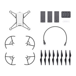
Specifications:

Instant Clarity. Superior Accuracy.

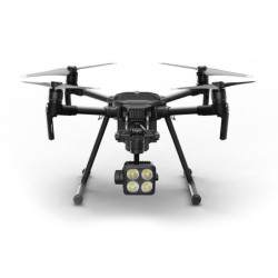
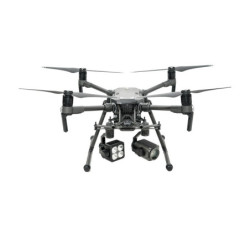
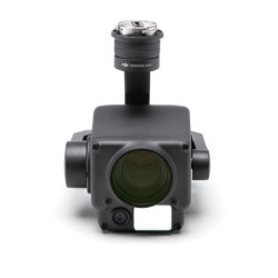
The Zenmuse L1 integrates a Livox Lidar module, a high-accuracy IMU, and a camera with a 1-inch CMOS on a 3-axis stabilized gimbal. When used with Matrice 300 RTK and DJI Terra, the L1 forms a complete solution that gives you real-time 3D data throughout the day, efficiently capturing the details of complex structures and delivering highly accurate reconstructed models.

Generate true-color point cloud models in real-time, or acquire 2 km2 of point cloud data in a single flight[1] using the Livox frame Lidar module with a 70° FOV and a visible light camera with a 1-inch sensor.

Render centimeter-accurate reconstructions thanks to the high-accuracy IMU, a vision sensor for positioning accuracy, and the incorporation of GNSS data.

The IP44 rating allows the L1 to be operated in rainy or foggy environments. The Lidar module’s active scanning method enables you to fly at night.
- Frame Lidar with up to 100% effective point cloud results
- Detection Range: 450m (80% reflectivity, 0 klx) / 190 m (10% reflectivity, 100 klx)
- Effective Point Rate: 240,000 pts/s
- Supports 3 Returns[3]
- Line Scan Mode and Non-repetitive Scan Mode


- 20MP
- 1-inch CMOS
- Mechanical Shutter
- Accuracy: 0.025° (roll/pitch) / 0.08° (yaw)
- Vision Sensor for Positioning Accuracy
- GNSS, IMU, RGB Data Fusion

Real-time point clouds provide immediate insights onsite, so operators are informed to make critical decisions quickly. You can also verify fieldwork quality by checking point cloud data immediately after each flight.
Acquire and communicate critical dimensions on the point cloud model using measurements and annotations.

DJI Terra fuses the IMU and GNSS data for point cloud and visible light calculations, in addition to conducting POS data calculations so you can effortlessly generate reconstructed models and accuracy reports.

Quickly generate topographic maps using accurate digital elevation models.

Manage the full project lifecycle using highly accurate point clouds and 3D models.

Any time of the day, gather critical insights in real-time using true-color point clouds.

Gain situational awareness and forensic intel in real-time to make informed decisions on site.

Model sparse or complex structures in detail to manage them efficiently and safely.

Gain insight into vegetation density, area, stock volume, canopy width, and growth trends.
| DJI Zenmuse L1 | |
|---|---|
| Product Name | Zenmuse L1 |
| Dimensions | 152×110×169 mm |
| Weight | 930±10 g |
| Power | Typical: 30 W; Max: 60 W |
| IP Rating | IP54 |
| Supported Aircraft | Matrice 300 RTK |
| Operating Temperature Range | -20° to 50° C 0° to 50° C (when using RGB mapping camera) |
| Storage Temperature Range | -20° to 60° C |
| System Performance | |
| Detection Range | 450 m @ 80% reflectivity, 0 klx; 190 m @ 10% reflectivity, 100 klx |
| Point Rate | Single return: 240,000 pts/s; Multiple return: 480,000 pts/s |
| System Accuracy | Horizontal: 10 cm @ 50 m; Vertical: 5 cm @ 50 m |
| Real-time Point Cloud Coloring Modes | Reflectivity, Height, Distance, RGB |
| Lidar | |
| Ranging Accuracy | 3 cm @ 100 m |
| Maximum Returns Supported | 3 |
| Scan Modes | Non-repetitive scanning pattern, Repetitive scanning pattern |
| FOV | Repetitive line scan: 70.4° (horizontal) ×4.5° (vertical); Non-repetitive scan: 70.4° (horizontal) ×77.2° (vertical) |
| Laser Safety | Class 1 (IEC 60825-1:2014) (Eye Safety) |
| Inertial Navigation System | |
| IMU Update Frequency | 200 Hz |
| Accelerometer Range | ±8 g |
| Angular Velocity Meter Range | ±2000 dps |
| Yaw Accuracy | Real-time: 0.3°, Post-processing: 0.15° |
| Pitch / Roll Accuracy | Real-time: 0.05°, Post-processing: 0.025° |
| Auxiliary Positioning Vision Sensor | |
| Resolution | 1280×960 |
| FOV | 95° |
| RGB Mapping Camera | |
| Sensor Size | 1 inch |
| Effective Pixels | 20 MP |
| Photo Size | 5472×3078 (16:9); 4864×3648 (4:3); 5472×3648 (3:2) |
| Focal Length | 8.8 mm / 24 mm (Equivalent) |
| Shutter Speed | Mechanical Shutter Speed: 1/2000 - 8 s Electronic Shutter Speed: 1/8000 - 8 s |
| ISO | Video: 100 – 3200 (Auto), 100 – 6400 (Manual) Photo: 100 - 3200 (Auto), 100 - 12800 (Manual) |
| Aperture Range | f/2.8 - f/11 |
| Supported File System | FAT (≤32 GB); exFAT (>32 GB) |
| Photo Format | JPEG |
| Video Format | MOV, MP4 |
| Video Resolution | H.264, 4K: 3840×2160 30p |
| Gimbal | |
| Stabilized System | 3-axis (tilt, roll, pan) |
| Angular Vibration Range | 0.01° |
| Mount | Detachable DJI SKYPORT |
| Mechanical Range | Tilt: -120° to +30°; Pan: ±320° |
| Operation Modes | Follow/Free/Re-center |
| Data Storage | |
| Raw Data Storage | Photo/IMU/Point cloud data storage/GNSS/Calibration files |
| Supported microSD Cards | microSD: Sequential writing speed 50 MB/s or above and UHS-I Speed Grade 3 rating or above; Max capacity: 256 GB |
| Recommended microSD Cards | SanDisk Extreme 128GB UHS-I Speed Grade 3 SanDisk Extreme 64GB UHS-I Speed Grade 3 SanDisk Extreme 32GB UHS-I Speed Grade 3 SanDisk Extreme 16GB UHS-I Speed Grade 3 Lexar 1066x 128GB U3 Samsung EVO Plus 128GB |
| Post-processing Software | |
| Supported Software | DJI Terra |
| Data Format | DJI Terra supports exporting standard format point cloud models: Point cloud format: PNTS/LAS/PLY/PCD/S3MB format |
Specifications: