Specifications:
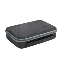
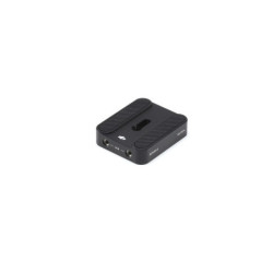
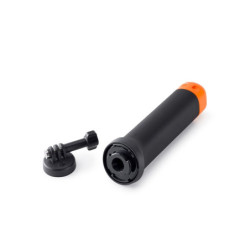
Each purchase of DJI Mavic 3 Multispectral comes with both of the following FREE combos: :
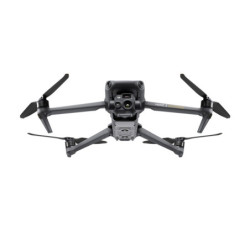
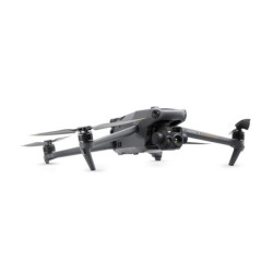
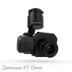
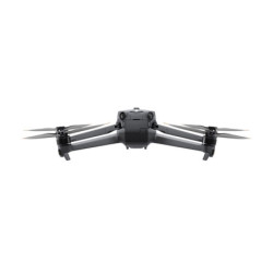
Effective aerial surveying needs to see the invisible. That's why Mavic 3 Multispectral has two forms of sight. It combines an RGB camera with a multispectral camera to scan and analyze crop growth with total clarity. Agricultural production management requires precision and data, and Mavic 3M delivers both.

Foldable for easy storage
4 × 5MP
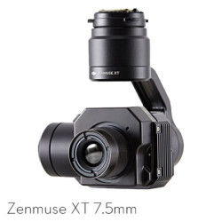
G/R/RE/NIR
20 MP
4/3 CMOS, mechanical shutter
Omnidirectional Obstacle Avoidance[1]
15km Transmission Distance[2]
Centimeter-level RTK positioning
Microsecond-level time synchronization
Up to 200 hectares per flight[3]

Newly upgraded imaging system with one 20MP RGB camera and four 5MP multispectral cameras (green, red, red edge, and near infrared). Enables applications such as high-precision aerial surveying, crop growth monitoring, and natural resource surveys.

20MP image sensor
Fastest mechanical shutter speed
High-speed burst when RGB camera is used

The built-in sunlight sensor captures solar irradiance and records it in an image file, allowing for light compensation of image data during 2D reconstruction. This results in more accurate NDVI results, as well as improved accuracy and consistency of data acquired over time.
Mavic 3M with RTK module for centimeter-level positioning. Flight control, the camera, and the RTK module sync in microseconds to accurately capture the location of each camera's imaging center. This enables Mavic 3M to do high-precision aerial surveying without using ground control points.
Cruise time
A single flight can complete mapping operations over an area of 200 hectares.

High-efficiency fast charging
Aircraft
The O3 transmission integrates two transmitting signals and four receiving signals to support 15km ultra-long transmission distances.
The aircraft features multiple wide-FOV vision sensors that accurately detect obstacles in all directions for omnidirectional obstacle avoidance. The terrain-follow aerial surveying can be easily performed in steep-slope landscapes.
Mavic 3M allows terrain-follow aerial surveying of orchards, even on sloped landscapes. Together with DJI Terra or DJI SmartFarm Platform[6] to reconstruct high-resolution orchard maps, automatically identify the number of trees, distinguish trees from other obstacles or objects, and generate three-dimensional operation routes for agricultural drones, making operations safer and more efficient.
For rice fertilization, cotton growth regulation, and potato foliar fertilizer spraying, the Mavic 3M is used to obtain multi-spectral images of crops. DJI Terra or the DJI SmartFarm Platform[6] can then generate NDVI and other vegetation indices maps, capturing differences in crop potential and generating prescription maps that allow agricultural drones to execute variable-rate application. This ultimately allows users to reduce costs, increase yield, and protect the environment.
The Mavic 3M can carry out automatic field scouting. The field scout images can be uploaded to the DJI SmartFarm Platform[6] in real time through a 4G network. It can find abnormalities, such as emergence deficiencies, weed pressure, and crop lodging in a timely manner. It can also conduct intelligent analyses, such as cotton seedling identification and rice production testing, using AI identification for real-time sharing of crop growth information, guidance of agronomic activities, and easy management of 70 hectares of farmland by one person.
The Mavic 3M can also be used in environment and natural resource surveys, such as water enrichment monitoring, forest distribution surveys, urban green area surveys, and more.


The Mavic 3M can be directly connected to a third-party cloud platform via Pilot 2's built-in DJI Cloud API based on the MQTT protocol. There is no need to develop an app separately to enable the transmission of UAV equipment information, live streaming, photo data, and other information.
The Mavic 3M supports Mobile SDK 5 (MSDK5) with a fully open-source production code sample. The MSDK5 makes it possible to develop a proprietary control app for UAV field patrol, smart surveying, and other scenarios, making it more user-friendly.
| Aircraft | |
|---|---|
| Net Weight (with propellers and RTK module) [1] | 951 g |
| Max Takeoff Weight | 1,050 g |
| Dimensions (Folded/Unfolded) | Folded (without propellers): 223×96.3×122.2 mm (Length×Width×Height) Unfolded (without propellers): 347.5×283×139.6 mm (Length×Width×Height) |
| Diagonal Length | Diagonal: 380.1 mm |
| Max Ascent Speed | 6 m/s (Normal Mode) 8 m/s (Sport Mode) |
| Max Descent Speed | 6 m/s (Normal Mode) 6 m/s (Sport Mode) |
| Max Flight Speed (at sea level, no wind) | 15 m/s (Normal Mode) Flying forward: 21 m/s, flying sideways: 20 m/s, flying backwards: 19 m/s (Sport mode) [2] |
| Max Wind Speed Resistance | 12 m/s [3] |
| Max Take-off Altitude Above Sea Level | 6000 m (without a payload) |
| Max Flight Time (without wind) | 43 minutes [4] |
| Max Hover Time (without wind) | 37 minutes [4] |
| Max Flight Distance | 32 km [6] |
| Max Tilt Angle | 30° (Normal Mode) 35° (Sport Mode) |
| Max Angular Velocity | 200°/s |
| GNSS | GPS + Galileo + BeiDou + GLONASS (GLONASS is supported only when RTK module is enabled) |
| Hovering Accuracy Range | Vertical: ±0.1 m (Vision Positioning enabled); ±0.5 m (GNSS Positioning enabled); ±0.1 m (D-RTK enabled) Horizontal: ±0.3 m (Vision Positioning enabled); ±0.5 m (HD Positioning enabled); ±0.1 m (RTK enabled) |
| Operating Temperature | -10° to 40° C (14° to 104° F) |
| Internal Storage | N/A |
| Motor Model Number | 2008 |
| Propeller Model Number | 9453F Enterprise Edition |
| Light Sensor | Built-in module |
| RGB camera | |
| Image Sensor | 4/3 CMOS Effective Pixels: 20 MP |
| Lens | FOV: 84° Equivalent focal length: 24 mm Aperture: f/2.8 to f/11 Focus: 1 m to ∞ |
| ISO Range | 100-6400 |
| Shutter speed | Electronic shutter: 8-1/8000 s Mechanical shutter: 8-1/2000 s |
| Max Image Size | 5280×3956 |
| Photo Shooting Mode | Single shot: 20 MP Timelapse: 20 MP JPEG: 0.7/1/2/3/5/7/10/15/20/30/60 s JPEG + RAW: 3/5/7/10/15/20/30/60 s Panorama: 20 MP (original material) |
| Video Resolution | H.264: 4K: 3840×2160@30fps FHD: 1920×1080@30fps |
| Max Video Bitrate | 4K: 130Mbps FHD: 70Mbps |
| Supported File System | exFAT |
| Image Format | JPEG/DNG (RAW) |
| Video Format | MP4 (MPEG-4 AVC/H.264) |
| Multispectral Camera | |
| Image Sensor | 1/2.8-inch CMOS, effective pixels: 5 MP |
| Lens | FOV: 73.91° (61.2° x 48.10°) Equivalent focal length: 25 mm Aperture: f/2.0 Focus: Fixed Focus |
| Multispectral Camera Band | Green (G): 550 ± 16 nm; Red (R): 650 ± 16 nm; Red Edge (RE): 730 ± 16 nm; Near infrared (NIR): 860 ± 26 nm; |
| Gain Range | 1x-32x |
| Shutter Speed | Electronic Shutter: 1/30~1/12800 s |
| Max Image Size | 2592×1944 |
| Image Format | TIFF |
| Video Format | MP4 (MPEG-4 AVC/H.264) |
| Photo Shooting Mode | Single shot: 5 MP Timelapse: 5 MP TIFF: 2/3/5/7/10/15/20/30/60 s |
| Video Resolution | H.264 FHD: 1920 x 1080@30fps Video content: NDVI/GNDVI/NDRE |
| Max Video Bitrate | Stream: 60 Mbps |
| Gimbal | |
| Stabilization System | 3-axis mechanical gimbal (tilt, roll, pan) |
| Mechanical Range | Tilt: -135° to 45° Roll: -45° to 45° Pan: -27° to 27° |
| Controllable Range | Tilt: -90° to 35° Pan: Uncontrollable |
| Max Control Speed (tilt) | 100°/s |
| Angular Vibration Range | ±0.007° |
| Sensing System | |
| Sensing System Type | Omnidirectional binocular vision system, with an infrared sensor at the bottom of the aircraft |
| Forward | Distance Measuring Range: 0.5 m to 20 m Detection Range: 0.5 m to 200 m Effective Obstacle Avoidance Speed: Flight Speed ≤15 m/s FOV: Horizontal 90°, vertical 103° |
| Backward | Distance Measuring Range: 0.5 m to 16 m Effective Obstacle Avoidance Speed: Flight speed ≤12 m/s FOV: Horizontal 90°, vertical 103° |
| Lateral | Distance Measuring Range: 0.5 m to 25 m Effective Obstacle Avoidance Speed: Flight speed ≤15 m/s FOV: Horizontal 90°, vertical 85° |
| Upward | Distance Measuring Range: 0.2 m to 10 m Effective Obstacle Avoidance Speed: Flight Speed ≤6 m/s FOV: Front and rear 100°, left and right 90° |
| Downward | Distance Measuring Range: 0.3 m to 18 m Effective Obstacle Avoidance Speed: Flight speed ≤6 m/s FOV: Front and rear 130°, left and right 160° |
| Operating Environment | Front, Rear, Left, Right, Above: Surfaces with clear patterns and adequate lighting (> 15 lux, environments with normal indoor fluorescent light exposure) Below: Surfaces with diffuse reflection material and a reflectivity of >20% (such as walls, trees, people, etc.); Adequate lighting (>15 lux, environments with normal indoor fluorescent light exposure) |
| Video Transmission | |
| Video Transmission System | DJI O3 Image Transmission Industry Edition |
| Live View Quality | Remote Controller: 1080p/30fps |
| Operating Band [7] | 2.400-2.4835 GHz 5.725-5.850 GHz |
| Max Effective Signal Distance (Unobstructed, No interference) [8] | FCC: 15 km CE: 8 km SRRC: 8 km MIC: 8 km |
| Max Transmission Distance (Obstructed) [9] | Strong Interference (urban landscapes, residential areas, etc.): 1.5-3 km (FCC/CE/SRRC/MIC) Medium Interference (suburban landscapes, city parks, etc.): 3-9 km (FCC), 3-6 km (CE/SRRC/MIC) Weak Interference (remote fields, open farmland, etc.): 9-15 km (FCC), 6-8 km (CE/SRRC/MIC) |
| Max Download Speed | 15 MB/s (with DJI RC Pro Industry Edition) |
| Latency (depending on environment and mobile device) | Approximately 200 milliseconds |
| Antennas | 4 antennas, 2 transmitting and 4 receiving |
| Transmitter Power (EIRP) | 2.4 GHz: <33 dBm (FCC), <20 dBm (CE/SRRC/MIC) 5.8 GHz: <33 dBm (FCC), <30 dBm (SRRC), <14 dBm (CE) |
| Other | Supports the DJI Cellular module |
| DJI RC Pro Enterprise Edition | |
| Image Transmission System | DJI O3 Image Transmission Industry Edition |
| Max Effective Signal Distance (Unobstructed, No interference) [8] | FCC: 15 km CE: 8 km SRRC: 8 km MIC: 8 km |
| Operating Band of Image Transmission [7] | 2.400-2.4835 GHz 5.725-5.850 GHz |
| Antennas | 4 antennas, 2 transmitting and 4 receiving |
| Operating Band of Image Transmission and Transmitter Power (EIRP) | 2.4 GHz: <33 dBm (FCC); <20 dBm (CE/SRRC/MIC) 5.8 GHz: <33 dBm (FCC); <14 dBm (CE); <23 dBm (SRRC) |
| Wi-Fi Protocol | 802.11 a/b/g/n/ac/ax Support 2×2 MIMO Wi-Fi |
| Wi-Fi Operating Band [7] | 2.400-2.4835 GHz 5.150-5.250 GHz 5.725-5.850 GHz |
| Wi-Fi Operating Band and Transmitter Power (EIRP) | 2.4 GHz: <26 dBm (FCC); <20 dBm (CE/SRRC/MIC) 5.1 GHz: <26 dBm (FCC); <23 dBm (CE/SRRC/MIC) 5.8 GHz: <26 dBm (FCC/SRRC); <14 dBm (CE) |
| Bluetooth Protocol | Bluetooth 5.1 |
| Bluetooth Operating Band | 2.400-2.4835 GHz |
| Bluetooth Transmitter Power (EIRP) | <10 dBm |
| Screen Resolution | 1920×1080 |
| Screen Size | 5.5 inches |
| Screen Frame Rate | 60 fps |
| Screen Brightness | 1,000 nits |
| Touch-Screen | 10-point multi-touch |
| Battery | Lithium-ion battery (5000 mAh, 7.2 V) |
| Charging Type | 100W Battery Charging Hub or USB charger with 12V or 15V specifications is recommended |
| Rated Power | 12 Watts |
| Storage Capacity | Internal Memory (ROM): 64 GB Supports microSD card usage to increase storage capacity |
| Charging Time | Approx. 1.5 hours (measured when only using the 100W Battery Charging Hub to charge the remote control, or when using a 15V USB charger) Approximately 2 hours (measured using a 12V USB charger) Approximately 2 hours and 50 minutes (measured using the 100W Battery Charging Hub to charge the aircraft and remote control at the same time) |
| Operating Time | Approx. 3 hours |
| Video Output Port | Mini-HDMI Port |
| Operating Temperature | -10° to 40° C (14° to 104°F) |
| Storage Temperature Range | <1 month: -30° to 60° C (-22° to 140° F) One to three months: -30° to 45° C (-22° to 113° F) Three to six months: -30° to 35° C (-22° to 95° F) More than six months: -30° to 25° C (-22° to 77° F) |
| Charging Temperature | 5° to 40° C (41° to 104° F) |
| Supported DJI Aircraft [10] | DJI Mavic 3E DJI Mavic 3T DJI Mavic 3M |
| GNSS | GPS + Galileo + GLONASS |
| Dimensions | Antenna is folded and no control sticks are installed: 183.27×137.41×47.6 mm (Length×Width×Height) Antenna unfolded and control sticks are installed: 183.27×203.35×59.84 mm (Length×Width×Height) |
| Weight | Approx. 680 g |
| Model Number | RM510B |
| Storage | |
| Supported microSD Cards | Aircraft: Please use a memory card with a speed rating of V30 or higher, or use a memory card from the recommended list |
| Recommended microSD Cards | Remote Controller: SanDisk Extreme PRO 64GB V30 A2 microSDXC SanDisk High Endurance 64GB V30 microSDXC SanDisk Extreme 128GB V30 A2 microSDXC SanDisk Extreme 256GB V30 A2 microSDXC SanDisk Extreme 512GB V30 A2 microSDXC Lexar 667x 64GB V30 A2 microSDXC Lexar High-Endurance 64GB V30 microSDXC Lexar High-Endurance 128GB V30 microSDXC Lexar 667x 256GB V30 A2 microSDXC Lexar 512GB V30 A2 microSDXC Samsung EVO Plus 64GB V30 microSDXC Samsung EVO Plus 128GB V30 microSDXC Samsung EVO Plus 256GB V30 microSDXC Samsung EVO Plus 512GB V30 microSDXC Kingston Canvas Go! Plus 128GB V30 A2 microSDXC Kingston Canvas React Plus 128GB V90 A1 microSDXC Aircraft: SanDisk Extreme 32GB V30 A1 microSDHC SanDisk Extreme PRO 32GB V30 A1 microSDHC SanDisk Extreme 512GB V30 A2 microSDXC Lexar 1066x 64GB V30 A2 microSDXC Kingston Canvas Go! Plus 64GB V30 A2 microSDXC Kingston Canvas React Plus 64GB V90 A1 microSDXC Kingston Canvas Go! Plus 128GB V30 A2 microSDXC Kingston Canvas React Plus 128GB V90 A1 microSDXC Kingston Canvas React Plus 256GB V90 A2 microSDXC Samsung PRO Plus 256GB V30 A2 microSDXC |
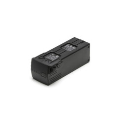
| Battery | |
| Capacity | 5000 mAh |
| Standard Voltage | 15.4 V |
| Max Charging Voltage | 17.6 V |
| Battery Type | LiPo 4S |
| Chemical System | Lithium Cobalt |
| Energy | 77 watt-hours |
| Weight | 335.5 g |
| Charging Temperature | 5° to 40° C (41° to 104° F) |
| Battery Charger | |
| Input | 100V to 240V (AC), 50Hz to 60Hz, 2.5A |
| Output Power | 100 Watts |
| Output | Maximum output power of 100 Watts (total) When both the ports are used, the maximum output power of one interface is 82 W, and the charger will dynamically allocate the output power of the two interfaces according to load power. |
| Charging Hub | |
| Input | USB-C: 5V to 20V, 5.0A |
| Output | Battery Port: 12V to 17.6V, 8.0A |
| Rated Power | 100 Watts |
| Charging Type | 3 batteries on charging rotation |
| Charging Temperature | 5° to 40° C (41° to 104° F) |
| RTK Module | |
| Dimensions | 50.2×40.2×66.2 mm (Length×Width×Height) |
| Weight | 24±2 g |
| Interface | USB-C |
| Power | Approximately 1.2 watts |
| RTK Position Accuracy | Fixed RTK: Horizontal: 1 cm + 1 ppm; Vertical: 1.5 cm + 1 ppm |
| Notes | |
| Footnotes | 1. Standard weight of the aircraft (including battery, propellers, and microSD card). The actual product weight may vary due to differences in batch materials and external factors. Use for reference only. 2. The max speed in the EU cannot exceed 19 m/s. 3. Max wind resistance during takeoff and landing. 4. Data measured using the DJI Mavic 3M in a wind-free environment while flying at sea level at a constant speed of 36 kph until there was 0% power remaining. For reference only. Please pay attention to Return to Home prompts in the DJI Pilot 2 app when flying. 5. Data measured using the DJI Mavic 3M in a wind-free environment hovering over the sea level until there was 0% power remaining. For reference only. Please pay attention to Return to Home prompts in the DJI Pilot 2 app when flying. 6. Data measured using the DJI Mavic 3M in a wind-free environment while flying at sea level at 57.6 kph until there was 0% power remaining. For reference only. Please pay attention to Return to Home prompts in the DJI Pilot 2 app when flying. 7. In some countries, the 5.1/5.8GHz frequencies are prohibited, or the 5.1GHz frequency is only allowed for indoor use. Please refer to local laws and regulations before use. 8. Data measured flying in an unobstructed outdoor environment free of interference. It shows the farthest communication range for one-way, non-Return to Home flights under each standard. Please pay attention to Return to Home prompts in the DJI Pilot 2 app when flying. 9. Data measured in an unobstructed environment with typical interference under various standards. The actual flight distance may vary and is for reference only. 10. The DJI RC Plus will support more DJI aircraft in the future. |
Specifications:
Each purchase of DJI Mavic 3 Multispectral comes with both of the following FREE combos: :